
Overview

The SHPO’s Hurricane Sandy program did not just assist property owners with repairs after Hurricane Sandy. Teams of consultants also surveyed thousands of historic properties, developed GIS databases, assisted towns with resiliency planning, nominated properties to the National Register of Historic Places—and much more
The historic buildings, structures, and sites of coastal Connecticut are increasingly in jeopardy from natural disasters like Superstorm Sandy and from the effects of climate change. The Connecticut State Historic Preservation Office (SHPO), Department of Economic and Community Development (DECD), is dedicated to protecting the state’s historic resources in the face of natural disasters such as nor’easters and hurricanes as well as sea level rise and other climate change impacts.
After Hurricane Sandy, the SHPO received $8.01 million from the National Park Service’s Emergency Supplemental Historic Preservation Fund (ESHPF) for historic preservation in the state’s four coastal counties. Initially, the SHPO developed a grant program to assist owners of historic properties that had been damaged by Sandy. Ultimately, grants were awarded to the owners of seven historic properties, ranging from an early nineteenth century lighthouse in Bridgeport to a late nineteenth century Gothic Revival mansion in New Haven to a nineteenth century beachfront barn-turned-park-amenity in Greenwich.
The SHPO designed much of its Hurricane Sandy program to promote resiliency for historic properties in the state’s coastal counties. In 2015, then-Governor Dannel P. Malloy announced a series of SHPO-led initiatives aimed at strengthening the state’s commitment to disaster preparation and response to protect historic and cultural resources in Connecticut’s coastal counties. Over the next four years, the SHPO carried out these initiatives as part of its Hurricane Sandy Disaster Relief Assistance Grant (DRAG) program, funded by a grant from the U.S. National Park Service.
To carry out the tasks, the SHPO contracted with R. Christopher Goodwin & Associates, Inc. (RCG&A), a cultural resources management firm based in Frederick, Maryland. RCG&A’s work in Connecticut ranged from architectural, archaeological, and underwater archaeological surveys to National Register of Historic Places nominations to resiliency planning assistance for municipalities. Additionally, RCG&A’s produced included historic resources databases and GIS mapping, survey reports, and historic context reports. The overarching goal: to strengthen the state’s capacity to plan for and respond to the effects of natural disasters and climate change on historic resources.
“The products and reports provided to the CT SHPO represent four years of multidisciplinary studies across the entire spectrum of historic preservation. This work will bolster consideration of historic properties in resiliency planning and disaster recovery for Connecticut’s coastal municipalities,” said Christopher Goodwin, president and CEO of RCG&A. “The efforts were truly rewarding for our entire team, and the far-reaching corpus of work surely will buttress Connecticut’s ability to manage and foster appreciation of the state’s invaluable historic resources.”
Added Peter Cropley, an RCG&A archaeologist who was involved in several of the firm’s projects in Connecticut: “The archaeological and historical resources of Connecticut are unique and irreplaceable. The preservation effort to document and engage with these sites, structures, landscapes, and other resources provides a valuable lesson for understanding the effects of climate change on past, present, and future residents of the State of Connecticut.”
The tasks included:
- Nominations of historic districts and individual properties to the National Register of Historic Places and State Register of Historic Places.
- Architectural surveys of selected coastal neighborhoods.
- Development of a searchable database of historic buildings, structures, and districts in the four coastal counties.
- Development of assessments and recommendations for historic resource resiliency planning in Connecticut.
- Survey of historic dams and development of a historic context for dams and associated resources.
- Archaeological survey and damage assessment of state-owned coastal properties.
- A GIS (geographic information system) database of Connecticut’s submerged cultural resources; surveys of submerged historic shipwrecks using shipboard instruments; development of underwater archaeological investigation guidelines.
- A post-disaster property survey form for homeowners in Connecticut.
- Ground truthing—the confirmation of geospatial data held in the searchable database of historic built resources through in-person checks of building locations.
- Guidance for cemetery researchers and surveyors; a GIS and database of the Charles R. Hale Collection of Connecticut cemetery records; development of an annotated reference guide for historic cemetery research; digitization of historic cemetery maps.
- Collection and synthesis of cultural resource data on the Stanton-Davis Homestead, a historic property and archaeological resource dating to 1700 in Stonington.
- Survey and evaluation of archaeological sites on state-owned properties.
- Booklets for three state-designated archeological preserves in coastal Connecticut.
- A historic context report on twentieth century architecture in Connecticut’s coastal counties.
- Resiliency planning assistance to regional Councils of Government (COGs) and municipalities in the four coastal counties.
- A guide to resiliency planning on a statewide level and recommendations for the State Historic Preservation Planning
- A Best Practices Guide for municipal planners on resiliency and historic preservation
- GIS database and site record linking of archaeological sites in the coastal counties.
- Public outreach, including articles, presentations, social media, and website materials.
- A guide to protecting historic buildings from the effects of climate change for property owners.
RCG&A’s cultural resources investigators—historians, architectural historians, terrestrial and marine archaeologists, GIS experts, and production staff—helped the SHPO gain a broad view of coastal Connecticut’s imperiled historic resources. The firm surveyed more than 2,500 historic buildings, structures, objects, and sites in addition to further documentation of new and previously recorded archaeological sites on land and underwater.
RCG&A’s team, which also included the planning and engineering firms Dewberry and Milone & MacBroom (subcontractors), also made the records of tens of thousands of additional resources—buildings, structures, archaeological sites, and cemeteries—readily available to the SHPO to search and map digitally.
The combination of surveys, digitization, GIS mapping, technical assistance, resiliency planning guides, and public outreach efforts have laid the groundwork for municipalities in the four coastal counties, and the State of Connecticut more generally, to enact a proactive approach combining historic preservation with resiliency against climate change hazards. Thanks to these efforts, Connecticut has been among the first states to address these planning issues on a statewide level.
By the numbers
3,153
Number of buildings surveyed in coastal Connecticut
854
Number of dams surveyed
50
Number of terrestrial archaeological sites surveyed
25
Number of underwater archaeological sites surveyed
21
Number of National Register and State Register nominations produced
1,112
Number of properties added to the National Register
1,261
Number of properties added to the State Register
45,288
Number of paper files on historic resources scanned and transferred to SHPO database
1,330
Number of cemeteries in GIS database
91
Number of towns whose plans for hazard mitigation, conservation and development, emergency operations, and coastal resiliency were analyzed for historic preservation gaps
33
Number of meetings with shoreline municipalities and regional Councils of Government on integrating historic preservation into resiliency planning
11 percent
Portion of the 36,000 historic buildings in coastal Connecticut that are at risk of flooding from storms or sea level rise
Photos from left:
1) A FEMA employee surveys damage in Milford after Hurricane Sandy. Credit: Robert Rose/FEMA
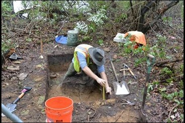
2) Archaeological testing at a coastal site. Credit: RCG&A